


Rando Chamesey

TRIMAILLE
Gebruiker
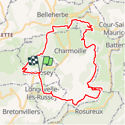

Lengte
22 km

Max. hoogte
845 m

Positief hoogteverschil
692 m
Km-Effort
31 km

Min. hoogte
491 m

Negatief hoogteverschil
696 m
Boucle
Ja
Datum van aanmaak :
2019-11-25 09:25:37.986
Laatste wijziging :
2019-11-27 10:36:46.007
6h28
Moeilijkheid : Moeilijk

Gratisgps-wandelapplicatie
 SityTrail
IGN / Geografische instituten
SityTrail Plus
De wereld gaat voor u open
Over ons
Tocht Stappen van 22 km beschikbaar op Bourgondië-Franche-Comté, Doubs, Chamesey. Deze tocht wordt voorgesteld door TRIMAILLE.
Plaatsbepaling
Land:
France
Regio :
Bourgondië-Franche-Comté
Departement/Provincie :
Doubs
Gemeente :
Chamesey
Locatie:
Unknown
Vertrek:(Dec)
Vertrek:(UTM)
322172 ; 5234129 (32T) N.
Opmerkingen