


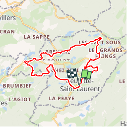
Beulotte-Saint-Laurent rando OVS

TRIMAILLE
Gebruiker

Lengte
15,9 km

Max. hoogte
755 m

Positief hoogteverschil
363 m
Km-Effort
21 km

Min. hoogte
595 m

Negatief hoogteverschil
373 m
Boucle
Ja
Datum van aanmaak :
2019-11-27 17:08:30.363
Laatste wijziging :
2019-11-27 17:15:17.064
4h26
Moeilijkheid : Medium

Gratisgps-wandelapplicatie
 SityTrail
IGN / Geografische instituten
SityTrail Plus
De wereld gaat voor u open
Over ons
Tocht Stappen van 15,9 km beschikbaar op Bourgondië-Franche-Comté, Haute-Saône, Beulotte-Saint-Laurent. Deze tocht wordt voorgesteld door TRIMAILLE.
Plaatsbepaling
Land:
France
Regio :
Bourgondië-Franche-Comté
Departement/Provincie :
Haute-Saône
Gemeente :
Beulotte-Saint-Laurent
Locatie:
Unknown
Vertrek:(Dec)
Vertrek:(UTM)
326317 ; 5303390 (32T) N.
Opmerkingen