


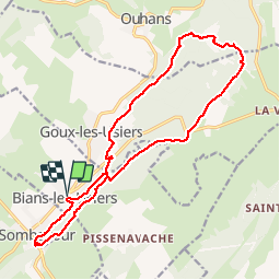
Bians-les-Usiers - rando CAF

TRIMAILLE
Gebruiker

Lengte
19,8 km

Max. hoogte
910 m

Positief hoogteverschil
486 m
Km-Effort
26 km

Min. hoogte
670 m

Negatief hoogteverschil
485 m
Boucle
Ja
Datum van aanmaak :
2019-12-01 14:38:53.19
Laatste wijziging :
2019-12-01 14:39:48.096
5h35
Moeilijkheid : Moeilijk

Gratisgps-wandelapplicatie
 SityTrail
IGN / Geografische instituten
SityTrail Plus
De wereld gaat voor u open
Over ons
Tocht Stappen van 19,8 km beschikbaar op Bourgondië-Franche-Comté, Doubs, Bians-les-Usiers. Deze tocht wordt voorgesteld door TRIMAILLE.
Plaatsbepaling
Land:
France
Regio :
Bourgondië-Franche-Comté
Departement/Provincie :
Doubs
Gemeente :
Bians-les-Usiers
Locatie:
Unknown
Vertrek:(Dec)
Vertrek:(UTM)
292230 ; 5204415 (32T) N.
Opmerkingen