


G2 fontaines

LUCIE2016
Gebruiker
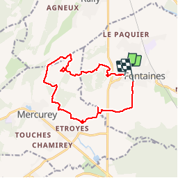

Lengte
13 km

Max. hoogte
364 m

Positief hoogteverschil
266 m
Km-Effort
16,6 km

Min. hoogte
197 m

Negatief hoogteverschil
268 m
Boucle
Neen
Datum van aanmaak :
2019-12-02 12:44:13.516
Laatste wijziging :
2019-12-02 15:28:40.702
2h43
Moeilijkheid : Heel gemakkelijk

Gratisgps-wandelapplicatie
 SityTrail
IGN / Geografische instituten
SityTrail Plus
De wereld gaat voor u open
Over ons
Tocht Stappen van 13 km beschikbaar op Bourgondië-Franche-Comté, Saône-et-Loire, Fontaines. Deze tocht wordt voorgesteld door LUCIE2016.
Plaatsbepaling
Land:
France
Regio :
Bourgondië-Franche-Comté
Departement/Provincie :
Saône-et-Loire
Gemeente :
Fontaines
Locatie:
Unknown
Vertrek:(Dec)
Vertrek:(UTM)
634203 ; 5189946 (31T) N.
Opmerkingen