


Bertimchamp

Michel Ruelens
Gebruiker
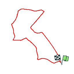

Lengte
8,5 km

Max. hoogte
161 m

Positief hoogteverschil
62 m
Km-Effort
9,3 km

Min. hoogte
138 m

Negatief hoogteverschil
61 m
Boucle
Ja
Datum van aanmaak :
2019-12-05 08:43:09.484
Laatste wijziging :
2019-12-05 10:42:20.722
1h58
Moeilijkheid : Heel gemakkelijk

Gratisgps-wandelapplicatie
 SityTrail
IGN / Geografische instituten
SityTrail Plus
De wereld gaat voor u open
Over ons
Tocht Noords wandelen van 8,5 km beschikbaar op Wallonië, Namen, Gembloers. Deze tocht wordt voorgesteld door Michel Ruelens.
Beschrijving
champêtre
Plaatsbepaling
Land:
Belgium
Regio :
Wallonië
Departement/Provincie :
Namen
Gemeente :
Gembloers
Locatie:
Grand-Manil
Vertrek:(Dec)
Vertrek:(UTM)
616234 ; 5601899 (31U) N.
Opmerkingen