


Caussols

verotrail
Gebruiker
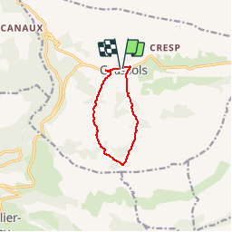

Lengte
8 km

Max. hoogte
1231 m

Positief hoogteverschil
205 m
Km-Effort
10,7 km

Min. hoogte
1091 m

Negatief hoogteverschil
201 m
Boucle
Ja
Datum van aanmaak :
2019-12-06 10:07:05.154
Laatste wijziging :
2019-12-06 10:24:10.668
--
Moeilijkheid : Heel gemakkelijk

Gratisgps-wandelapplicatie
 SityTrail
IGN / Geografische instituten
SityTrail Plus
De wereld gaat voor u open
Over ons
Tocht Te voet van 8 km beschikbaar op Provence-Alpes-Côte d'Azur, Alpes-Maritimes, Caussols. Deze tocht wordt voorgesteld door verotrail.
Plaatsbepaling
Land:
France
Regio :
Provence-Alpes-Côte d'Azur
Departement/Provincie :
Alpes-Maritimes
Gemeente :
Caussols
Locatie:
Unknown
Vertrek:(Dec)
Vertrek:(UTM)
330877 ; 4845312 (32T) N.
Opmerkingen