


Maredsous

dewaeph
Gebruiker

Lengte
14,4 km

Max. hoogte
283 m

Positief hoogteverschil
311 m
Km-Effort
18,6 km

Min. hoogte
176 m

Negatief hoogteverschil
310 m
Boucle
Neen
Datum van aanmaak :
2019-12-14 09:13:19.379
Laatste wijziging :
2019-12-14 14:07:08.256
4h53
Moeilijkheid : Heel gemakkelijk

Gratisgps-wandelapplicatie
 SityTrail
IGN / Geografische instituten
SityTrail Plus
De wereld gaat voor u open
Over ons
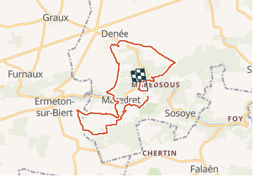
Tocht Stappen van 14,4 km beschikbaar op Wallonië, Namen, Anhée. Deze tocht wordt voorgesteld door dewaeph.
Plaatsbepaling
Land:
Belgium
Regio :
Wallonië
Departement/Provincie :
Namen
Gemeente :
Anhée
Locatie:
Denée
Vertrek:(Dec)
Vertrek:(UTM)
625746 ; 5573544 (31U) N.
Opmerkingen