


Vecquée par bas (DATS)

thomarche
Gebruiker
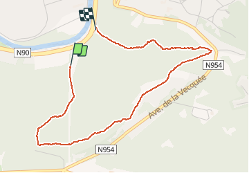

Lengte
4,1 km

Max. hoogte
224 m

Positief hoogteverschil
118 m
Km-Effort
5,7 km

Min. hoogte
91 m

Negatief hoogteverschil
139 m
Boucle
Neen
Datum van aanmaak :
2019-12-25 14:19:44.0
Laatste wijziging :
2019-12-25 15:28:36.844
1h06
Moeilijkheid : Onbekend

Gratisgps-wandelapplicatie
 SityTrail
IGN / Geografische instituten
SityTrail Plus
De wereld gaat voor u open
Over ons
Tocht Stappen van 4,1 km beschikbaar op Wallonië, Namen, Namen. Deze tocht wordt voorgesteld door thomarche.
Plaatsbepaling
Land:
Belgium
Regio :
Wallonië
Departement/Provincie :
Namen
Gemeente :
Namen
Locatie:
Malonne
Vertrek:(Dec)
Vertrek:(UTM)
630062 ; 5590002 (31U) N.
Opmerkingen