![](/images/other/stat-length.png)
![Tocht Te voet Saint-Laurent-de-Brèvedent - saint laurent de Brevedent - Photo](https://media.geolcdn.com/t/1900/400/ext.pjpeg?maxdim=2&url=https%3A%2F%2Fstatic1.geolcdn.com%2Fsiteimages%2Fupload%2Ffiles%2F1545311037marcheuse_200dpi.jpg)
saint laurent de Brevedent
AACLARANDO
ensemble sur les chemins
![Lengte](/images/other/stat-length.png)
Lengte
11,3 km
![Max. hoogte](https://static1.geolcdn.com/siteimages/upload/files/1508320355ic_sort_altitude_max_24dp.png)
Max. hoogte
107 m
![Positief hoogteverschil](https://static1.geolcdn.com/siteimages/upload/files/1508320355ic_sort_den_pos_24dp.png)
Positief hoogteverschil
168 m
![Km-Effort](/images/other/stat-length.png)
Km-Effort
13,6 km
![Min. hoogte](https://static1.geolcdn.com/siteimages/upload/files/1508320355ic_sort_altitude_min_24dp.png)
Min. hoogte
32 m
![Negatief hoogteverschil](https://static1.geolcdn.com/siteimages/upload/files/1508320355ic_sort_den_neg_24dp.png)
Negatief hoogteverschil
168 m
![Boucle](https://static1.geolcdn.com/siteimages/upload/files/16400158638029165_repeat_loop_refresh_sync_direction_icon.png)
Boucle
Ja
Datum van aanmaak :
2019-12-27 11:37:31.664
Laatste wijziging :
2019-12-27 11:41:50.442
![Te voet](https://static1.geolcdn.com/sitytour/trail-icons/100.png)
--
Moeilijkheid : Gemakkelijk
![Scan deze QR-code om de tocht te openen in de SityTrail-applicatie](https://capi.geolives.com/qq0zvz2zws4bq2lad0pu/sitytour/trails/2291180/qr.png?size=200)
Gratisgps-wandelapplicatie
Over ons
Tocht Te voet van 11,3 km beschikbaar op Normandië, Seine-Maritime, Saint-Laurent-de-Brèvedent. Deze tocht wordt voorgesteld door AACLARANDO.
Beschrijving
Circuit long. Chemins herbeux, forets et petites routes goudronnées.
Plaatsbepaling
Land:
France
Regio :
Normandië
Departement/Provincie :
Seine-Maritime
Gemeente :
Saint-Laurent-de-Brèvedent
Locatie:
Unknown
Vertrek:(Dec)
Vertrek:(UTM)
301726 ; 5490317 (31U) N.
Opmerkingen
Wandeltochten in de omgeving
![Tocht Stappen Harfleur - Turner's walk - Photo](https://media.geolcdn.com/t/375/260/ext.jpg?maxdim=2&url=https%3A%2F%2Fservices.sitytrail.com%2FGeolivesWS%2FDownloadMedia.ashx%3FTrailID%3D338140%26Media%3D38869f3e-a905-416b-990a-9713f7dd7e14.jpg)
![Stappen Stappen](https://static1.geolcdn.com/sitytour/trail-icons/101.png)
Turner's walk
Stappen
Gemakkelijk
(1)
Harfleur,
Normandië,
Seine-Maritime,
France
![](/images/other/stat-length.png)
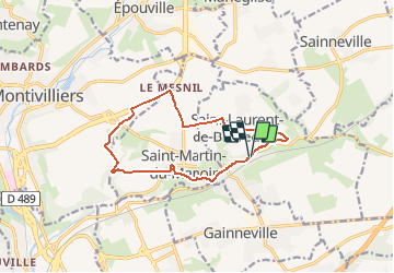
7,7 km | 9,1 km-effort
3h 0min
![](https://static1.geolcdn.com/siteimages/upload/files/16400158638029165_repeat_loop_refresh_sync_direction_icon.png)
Ja
![Tocht Stappen Saint-Martin-du-Manoir - st Martin - st Laurent - Photo](https://media.geolcdn.com/t/375/260/ext.jpg?maxdim=2&url=https%3A%2F%2Fstatic1.geolcdn.com%2Fsiteimages%2Fupload%2Ffiles%2F1553511878bg_sport_marche.png)
![Stappen Stappen](https://static1.geolcdn.com/sitytour/trail-icons/101.png)
st Martin - st Laurent
Stappen
Moeilijk
(1)
Saint-Martin-du-Manoir,
Normandië,
Seine-Maritime,
France
![](/images/other/stat-length.png)
10,6 km | 12,7 km-effort
2h 52min
![](https://static1.geolcdn.com/siteimages/upload/files/16400158638029165_repeat_loop_refresh_sync_direction_icon.png)
Ja
![Tocht Stappen Épouville - epouville 7,8 - Photo](https://media.geolcdn.com/t/375/260/ext.jpg?maxdim=2&url=https%3A%2F%2Fstatic1.geolcdn.com%2Fsiteimages%2Fupload%2Ffiles%2F1553511878bg_sport_marche.png)
![Stappen Stappen](https://static1.geolcdn.com/sitytour/trail-icons/101.png)
epouville 7,8
Stappen
Medium
(1)
Épouville,
Normandië,
Seine-Maritime,
France
![](/images/other/stat-length.png)
7,8 km | 9,3 km-effort
2h 6min
![](https://static1.geolcdn.com/siteimages/upload/files/16400158638029165_repeat_loop_refresh_sync_direction_icon.png)
Ja
![Tocht Te voet Sainneville - Autour de Sainneville sur Seine - Photo](https://media.geolcdn.com/t/375/260/ext.jpg?maxdim=2&url=https%3A%2F%2Fstatic1.geolcdn.com%2Fsiteimages%2Fupload%2Ffiles%2F1545311037marcheuse_200dpi.jpg)
![Te voet Te voet](https://static1.geolcdn.com/sitytour/trail-icons/100.png)
Autour de Sainneville sur Seine
Te voet
Gemakkelijk
(1)
Sainneville,
Normandië,
Seine-Maritime,
France
![](/images/other/stat-length.png)
6,1 km | 6,7 km-effort
1h 31min
![](https://static1.geolcdn.com/siteimages/upload/files/16400158638029165_repeat_loop_refresh_sync_direction_icon.png)
Ja
![Tocht Stappen Gainneville - Tour de St Laurent de Brevedent variante N°3 - Photo](https://media.geolcdn.com/t/375/260/ext.jpg?maxdim=2&url=https%3A%2F%2Fstatic1.geolcdn.com%2Fsiteimages%2Fupload%2Ffiles%2F1553511878bg_sport_marche.png)
![Stappen Stappen](https://static1.geolcdn.com/sitytour/trail-icons/101.png)
Tour de St Laurent de Brevedent variante N°3
Stappen
Heel gemakkelijk
(1)
Gainneville,
Normandië,
Seine-Maritime,
France
![](/images/other/stat-length.png)
10,4 km | 12,7 km-effort
2h 42min
![](https://static1.geolcdn.com/siteimages/upload/files/16400158638029165_repeat_loop_refresh_sync_direction_icon.png)
Ja
![Tocht Stappen Épouville - Epouville / Le Gray / La Lézarde /Epouville - Photo](https://media.geolcdn.com/t/375/260/ext.jpg?maxdim=2&url=https%3A%2F%2Fstatic1.geolcdn.com%2Fsiteimages%2Fupload%2Ffiles%2F1553511878bg_sport_marche.png)
![Stappen Stappen](https://static1.geolcdn.com/sitytour/trail-icons/101.png)
Epouville / Le Gray / La Lézarde /Epouville
Stappen
Medium
(1)
Épouville,
Normandië,
Seine-Maritime,
France
![](/images/other/stat-length.png)
8,6 km | 10,3 km-effort
2h 20min
![](https://static1.geolcdn.com/siteimages/upload/files/16400158638029165_repeat_loop_refresh_sync_direction_icon.png)
Ja
![Tocht Stappen Étainhus - etainhus sur romain - Photo](https://media.geolcdn.com/t/375/260/ext.jpg?maxdim=2&url=https%3A%2F%2Fmedia.geolcdn.com%2Ff%2F41a320f0-00d5-4384-bb9e-c6b1373f691d.jpg)
![Stappen Stappen](https://static1.geolcdn.com/sitytour/trail-icons/101.png)
etainhus sur romain
Stappen
Medium
Étainhus,
Normandië,
Seine-Maritime,
France
![](/images/other/stat-length.png)
11,7 km | 13,4 km-effort
2h 53min
![](https://static1.geolcdn.com/siteimages/upload/files/16400158638029165_repeat_loop_refresh_sync_direction_icon.png)
Ja
![Tocht Stappen Saint-Laurent-de-Brèvedent - st Laurent revede.t - Photo](https://media.geolcdn.com/t/375/260/ext.jpg?maxdim=2&url=https%3A%2F%2Fmedia.geolcdn.com%2Ff%2F5097ace2-85a6-4fdb-9d65-32bd50b8dcf4.jpg)
![Stappen Stappen](https://static1.geolcdn.com/sitytour/trail-icons/101.png)
st Laurent revede.t
Stappen
Medium
Saint-Laurent-de-Brèvedent,
Normandië,
Seine-Maritime,
France
![](/images/other/stat-length.png)
13,1 km | 15,6 km-effort
3h 10min
![](https://static1.geolcdn.com/siteimages/upload/files/16400158638029165_repeat_loop_refresh_sync_direction_icon.png)
Ja
![Tocht Stappen Gainneville - Gainneville église / Gournay / St Martin / Gainneville église - Photo](https://media.geolcdn.com/t/375/260/ext.jpg?maxdim=2&url=https%3A%2F%2Fmedia.geolcdn.com%2Ff%2Ff5ee4f8e-4f96-41e4-8426-318e8030de67.jpg)
![Stappen Stappen](https://static1.geolcdn.com/sitytour/trail-icons/101.png)
Gainneville église / Gournay / St Martin / Gainneville église
Stappen
Medium
Gainneville,
Normandië,
Seine-Maritime,
France
![](/images/other/stat-length.png)
9 km | 11,2 km-effort
2h 32min
![](https://static1.geolcdn.com/siteimages/upload/files/16400158638029165_repeat_loop_refresh_sync_direction_icon.png)
Ja