


Hoge Veluwe

dewaeph
Gebruiker
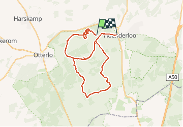

Lengte
32 km

Max. hoogte
59 m

Positief hoogteverschil
256 m
Km-Effort
35 km

Min. hoogte
29 m

Negatief hoogteverschil
251 m
Boucle
Neen
Datum van aanmaak :
2020-01-06 10:03:23.306
Laatste wijziging :
2020-01-06 16:06:03.916
6h02
Moeilijkheid : Heel gemakkelijk

Gratisgps-wandelapplicatie
 SityTrail
IGN / Geografische instituten
SityTrail Plus
De wereld gaat voor u open
Over ons
Tocht Fietstoerisme van 32 km beschikbaar op Gelderland, Onbekend, Ede. Deze tocht wordt voorgesteld door dewaeph.
Plaatsbepaling
Land:
Netherlands
Regio :
Gelderland
Departement/Provincie :
Onbekend
Gemeente :
Ede
Locatie:
Unknown
Vertrek:(Dec)
Vertrek:(UTM)
694723 ; 5777928 (31U) N.
Opmerkingen