


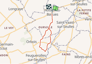
Hottot les Bagues 9 kms 2020

aubinjoel
Gebruiker

Lengte
8,9 km

Max. hoogte
124 m

Positief hoogteverschil
151 m
Km-Effort
11 km

Min. hoogte
71 m

Negatief hoogteverschil
149 m
Boucle
Ja
Datum van aanmaak :
2020-01-16 15:01:49.258
Laatste wijziging :
2020-01-16 15:03:29.105

Gratisgps-wandelapplicatie
 SityTrail
IGN / Geografische instituten
SityTrail Plus
De wereld gaat voor u open
Over ons
Tocht van 8,9 km beschikbaar op Normandië, Calvados, Hottot-les-Bagues. Deze tocht wordt voorgesteld door aubinjoel.
Plaatsbepaling
Land:
France
Regio :
Normandië
Departement/Provincie :
Calvados
Gemeente :
Hottot-les-Bagues
Locatie:
Unknown
Vertrek:(Dec)
Vertrek:(UTM)
671351 ; 5446980 (30U) N.
Opmerkingen