


s s Laurent

jouniaux.guy
Gebruiker

Lengte
9 km

Max. hoogte
230 m

Positief hoogteverschil
64 m
Km-Effort
9,8 km

Min. hoogte
184 m

Negatief hoogteverschil
64 m
Boucle
Ja
Datum van aanmaak :
2014-12-10 00:00:00.0
Laatste wijziging :
2014-12-10 00:00:00.0
2h12
Moeilijkheid : Heel gemakkelijk

Gratisgps-wandelapplicatie
 SityTrail
IGN / Geografische instituten
SityTrail Plus
De wereld gaat voor u open
Over ons
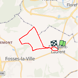
Tocht Stappen van 9 km beschikbaar op Wallonië, Namen, Fosses-la-Ville. Deze tocht wordt voorgesteld door jouniaux.guy.
Plaatsbepaling
Land:
Belgium
Regio :
Wallonië
Departement/Provincie :
Namen
Gemeente :
Fosses-la-Ville
Locatie:
Sart-Saint-Laurent
Vertrek:(Dec)
Vertrek:(UTM)
623760 ; 5584812 (31U) N.
Opmerkingen