


ils de la jatte

GOELERANDO2
Gebruiker
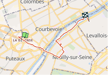

Lengte
5,9 km

Max. hoogte
62 m

Positief hoogteverschil
73 m
Km-Effort
6,9 km

Min. hoogte
0 m

Negatief hoogteverschil
99 m
Boucle
Neen
Datum van aanmaak :
2020-01-21 12:43:11.715
Laatste wijziging :
2020-01-28 14:12:27.153
2h01
Moeilijkheid : Heel gemakkelijk

Gratisgps-wandelapplicatie
 SityTrail
IGN / Geografische instituten
SityTrail Plus
De wereld gaat voor u open
Over ons
Tocht Stappen van 5,9 km beschikbaar op Île-de-France, Hauts-de-Seine, Puteaux. Deze tocht wordt voorgesteld door GOELERANDO2.
Beschrijving
rando
Plaatsbepaling
Land:
France
Regio :
Île-de-France
Departement/Provincie :
Hauts-de-Seine
Gemeente :
Puteaux
Locatie:
Unknown
Vertrek:(Dec)
Vertrek:(UTM)
444317 ; 5415564 (31U) N.
Opmerkingen