


saint Sébastien d aigre feuille arsel

labarone
Gebruiker

Lengte
21 km

Max. hoogte
648 m

Positief hoogteverschil
808 m
Km-Effort
32 km

Min. hoogte
192 m

Negatief hoogteverschil
808 m
Boucle
Ja
Datum van aanmaak :
2020-01-28 08:18:15.091
Laatste wijziging :
2020-01-29 21:34:35.114
5h45
Moeilijkheid : Gemakkelijk

Gratisgps-wandelapplicatie
 SityTrail
IGN / Geografische instituten
SityTrail Plus
De wereld gaat voor u open
Over ons
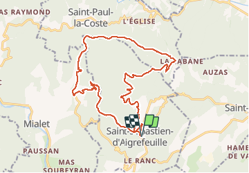
Tocht Stappen van 21 km beschikbaar op Occitanië, Gard, Saint-Sébastien-d'Aigrefeuille. Deze tocht wordt voorgesteld door labarone.
Beschrijving
Belle rando tranquille
Attention certaines revues telle que " les plus belles rando des cevennes" indiquent 17 kms5 alors qu elle fait 21 kms
Foto's


Plaatsbepaling
Land:
France
Regio :
Occitanië
Departement/Provincie :
Gard
Gemeente :
Saint-Sébastien-d'Aigrefeuille
Locatie:
Unknown
Vertrek:(Dec)
Vertrek:(UTM)
579607 ; 4884196 (31T) N.
Opmerkingen