


2020-01-29_23h49m32_Sur les traces de Manon
immortelles2020
prendre plaisir à faire plaisir
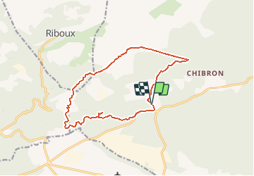

Lengte
12,9 km

Max. hoogte
561 m

Positief hoogteverschil
249 m
Km-Effort
16,3 km

Min. hoogte
384 m

Negatief hoogteverschil
254 m
Boucle
Ja
Datum van aanmaak :
2020-01-29 22:49:32.643
Laatste wijziging :
2025-02-11 06:45:47.122
3h41
Moeilijkheid : Gemakkelijk

Gratisgps-wandelapplicatie
 SityTrail
IGN / Geografische instituten
SityTrail Plus
De wereld gaat voor u open
Over ons
Tocht Stappen van 12,9 km beschikbaar op Provence-Alpes-Côte d'Azur, Var, Signes. Deze tocht wordt voorgesteld door immortelles2020.
Beschrijving
facile
Plaatsbepaling
Land:
France
Regio :
Provence-Alpes-Côte d'Azur
Departement/Provincie :
Var
Gemeente :
Signes
Locatie:
Unknown
Vertrek:(Dec)
Vertrek:(UTM)
727288 ; 4795454 (31T) N.
Opmerkingen