


Rando Pt Ste Maxence

domifon
Gebruiker
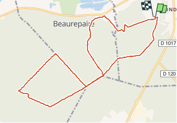

Lengte
12,3 km

Max. hoogte
123 m

Positief hoogteverschil
179 m
Km-Effort
14,7 km

Min. hoogte
37 m

Negatief hoogteverschil
178 m
Boucle
Ja
Datum van aanmaak :
2014-12-10 00:00:00.0
Laatste wijziging :
2014-12-10 00:00:00.0
2h21
Moeilijkheid : Gemakkelijk

Gratisgps-wandelapplicatie
 SityTrail
IGN / Geografische instituten
SityTrail Plus
De wereld gaat voor u open
Over ons
Tocht Mountainbike van 12,3 km beschikbaar op Hauts-de-France, Oise, Pont-Sainte-Maxence. Deze tocht wordt voorgesteld door domifon.


Plaatsbepaling
Land:
France
Regio :
Hauts-de-France
Departement/Provincie :
Oise
Gemeente :
Pont-Sainte-Maxence
Locatie:
Unknown
Vertrek:(Dec)
Vertrek:(UTM)
470778 ; 5460065 (31U) N.
Opmerkingen
