


Rivière Rouge

DaVinci
Gebruiker

Lengte
25 km

Max. hoogte
212 m

Positief hoogteverschil
133 m
Km-Effort
27 km

Min. hoogte
194 m

Negatief hoogteverschil
143 m
Boucle
Neen
Datum van aanmaak :
2020-02-03 18:15:57.134
Laatste wijziging :
2020-02-03 18:16:40.582
4h10
Moeilijkheid : Medium

Gratisgps-wandelapplicatie
 SityTrail
IGN / Geografische instituten
SityTrail Plus
De wereld gaat voor u open
Over ons
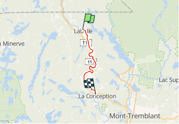
Tocht Kanoën - kajakken van 25 km beschikbaar op Quebec, Les Laurentides, Labelle. Deze tocht wordt voorgesteld door DaVinci.
Plaatsbepaling
Land:
Canada
Regio :
Quebec
Departement/Provincie :
Les Laurentides
Gemeente :
Labelle
Locatie:
Unknown
Vertrek:(Dec)
Vertrek:(UTM)
520581 ; 5125299 (18T) N.
Opmerkingen