


Rando Vouneuil-sous-Biard

Arnaud Dejean
Gebruiker
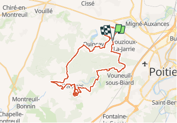

Lengte
39 km

Max. hoogte
150 m

Positief hoogteverschil
494 m
Km-Effort
46 km

Min. hoogte
84 m

Negatief hoogteverschil
494 m
Boucle
Ja
Datum van aanmaak :
2020-02-06 10:36:13.914
Laatste wijziging :
2020-02-06 15:46:53.277
4h23
Moeilijkheid : Medium

Gratisgps-wandelapplicatie
 SityTrail
IGN / Geografische instituten
SityTrail Plus
De wereld gaat voor u open
Over ons
Tocht Mountainbike van 39 km beschikbaar op Nieuw-Aquitanië, Vienne, Vouneuil-sous-Biard. Deze tocht wordt voorgesteld door Arnaud Dejean.
Plaatsbepaling
Land:
France
Regio :
Nieuw-Aquitanië
Departement/Provincie :
Vienne
Gemeente :
Vouneuil-sous-Biard
Locatie:
Unknown
Vertrek:(Dec)
Vertrek:(UTM)
290473 ; 5165527 (31T) N.
Opmerkingen