


Le Pradet les forts

jlnessy
Gebruiker
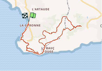

Lengte
14,5 km

Max. hoogte
281 m

Positief hoogteverschil
566 m
Km-Effort
22 km

Min. hoogte
-1 m

Negatief hoogteverschil
564 m
Boucle
Ja
Datum van aanmaak :
2020-02-06 08:24:24.401
Laatste wijziging :
2020-02-06 22:53:46.295
5h51
Moeilijkheid : Gemakkelijk

Gratisgps-wandelapplicatie
 SityTrail
IGN / Geografische instituten
SityTrail Plus
De wereld gaat voor u open
Over ons
Tocht Stappen van 14,5 km beschikbaar op Provence-Alpes-Côte d'Azur, Var, Le Pradet. Deze tocht wordt voorgesteld door jlnessy.
Plaatsbepaling
Land:
France
Regio :
Provence-Alpes-Côte d'Azur
Departement/Provincie :
Var
Gemeente :
Le Pradet
Locatie:
Unknown
Vertrek:(Dec)
Vertrek:(UTM)
257898 ; 4775416 (32T) N.
Opmerkingen