


2020 02 EVRY T1

michel1025
Gebruiker
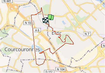

Lengte
10,1 km

Max. hoogte
90 m

Positief hoogteverschil
82 m
Km-Effort
11,2 km

Min. hoogte
59 m

Negatief hoogteverschil
83 m
Boucle
Ja
Datum van aanmaak :
2020-02-07 08:27:44.0
Laatste wijziging :
2020-02-07 15:18:44.77
2h04
Moeilijkheid : Onbekend

Gratisgps-wandelapplicatie
 SityTrail
IGN / Geografische instituten
SityTrail Plus
De wereld gaat voor u open
Over ons
Tocht Stappen van 10,1 km beschikbaar op Île-de-France, Essonne, Évry-Courcouronnes. Deze tocht wordt voorgesteld door michel1025.
Plaatsbepaling
Land:
France
Regio :
Île-de-France
Departement/Provincie :
Essonne
Gemeente :
Évry-Courcouronnes
Locatie:
Courcouronnes
Vertrek:(Dec)
Vertrek:(UTM)
457510 ; 5386221 (31U) N.
Opmerkingen