


moncheaux rl

jeanluc59
Gebruiker
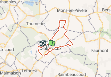

Lengte
11,1 km

Max. hoogte
74 m

Positief hoogteverschil
79 m
Km-Effort
12,1 km

Min. hoogte
41 m

Negatief hoogteverschil
79 m
Boucle
Ja
Datum van aanmaak :
2020-02-10 19:23:26.897
Laatste wijziging :
2020-02-10 19:24:25.537
--
Moeilijkheid : Gemakkelijk

Gratisgps-wandelapplicatie
 SityTrail
IGN / Geografische instituten
SityTrail Plus
De wereld gaat voor u open
Over ons
Tocht Te voet van 11,1 km beschikbaar op Hauts-de-France, Noorderdepartement, Moncheaux. Deze tocht wordt voorgesteld door jeanluc59.
Plaatsbepaling
Land:
France
Regio :
Hauts-de-France
Departement/Provincie :
Noorderdepartement
Gemeente :
Moncheaux
Locatie:
Unknown
Vertrek:(Dec)
Vertrek:(UTM)
505622 ; 5589049 (31U) N.
Opmerkingen