


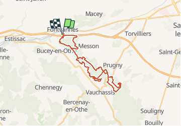
fontvannes 16 02 20

Tollard
Gebruiker

Lengte
30 km

Max. hoogte
270 m

Positief hoogteverschil
541 m
Km-Effort
37 km

Min. hoogte
147 m

Negatief hoogteverschil
541 m
Boucle
Ja
Datum van aanmaak :
2020-02-16 07:41:49.275
Laatste wijziging :
2020-02-25 16:23:53.241
3h10
Moeilijkheid : Medium

Gratisgps-wandelapplicatie
 SityTrail
IGN / Geografische instituten
SityTrail Plus
De wereld gaat voor u open
Over ons
Tocht Mountainbike van 30 km beschikbaar op Grand Est, Aube, Fontvannes. Deze tocht wordt voorgesteld door Tollard.
Plaatsbepaling
Land:
France
Regio :
Grand Est
Departement/Provincie :
Aube
Gemeente :
Fontvannes
Locatie:
Unknown
Vertrek:(Dec)
Vertrek:(UTM)
564736 ; 5347029 (31U) N.
Opmerkingen