


Fontan - Mt Maraute

aris
Gebruiker
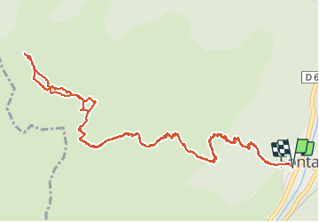

Lengte
8,2 km

Max. hoogte
1326 m

Positief hoogteverschil
885 m
Km-Effort
20 km

Min. hoogte
429 m

Negatief hoogteverschil
887 m
Boucle
Ja
Datum van aanmaak :
2020-03-01 08:39:33.798
Laatste wijziging :
2020-03-01 15:48:47.121
4h06
Moeilijkheid : Gemakkelijk

Gratisgps-wandelapplicatie
 SityTrail
IGN / Geografische instituten
SityTrail Plus
De wereld gaat voor u open
Over ons
Tocht Stappen van 8,2 km beschikbaar op Provence-Alpes-Côte d'Azur, Alpes-Maritimes, Fontan. Deze tocht wordt voorgesteld door aris.
Beschrijving
Petite rando d'hiver tranquille en alpage. Aucune difficulté, accès hors sentier facile au sommet.
Plaatsbepaling
Land:
France
Regio :
Provence-Alpes-Côte d'Azur
Departement/Provincie :
Alpes-Maritimes
Gemeente :
Fontan
Locatie:
Unknown
Vertrek:(Dec)
Vertrek:(UTM)
383989 ; 4873163 (32T) N.
Opmerkingen