


Hiv2020 P3 V6

PhilippeC54
Gebruiker
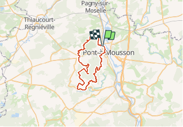

Lengte
44 km

Max. hoogte
380 m

Positief hoogteverschil
799 m
Km-Effort
55 km

Min. hoogte
177 m

Negatief hoogteverschil
801 m
Boucle
Ja
Datum van aanmaak :
2020-03-04 15:32:34.834
Laatste wijziging :
2020-03-04 15:32:34.834
--
Moeilijkheid : Onbekend

Gratisgps-wandelapplicatie
 SityTrail
IGN / Geografische instituten
SityTrail Plus
De wereld gaat voor u open
Over ons
Tocht Mountainbike van 44 km beschikbaar op Grand Est, Meurthe-et-Moselle, Pont-à-Mousson. Deze tocht wordt voorgesteld door PhilippeC54.
Plaatsbepaling
Land:
France
Regio :
Grand Est
Departement/Provincie :
Meurthe-et-Moselle
Gemeente :
Pont-à-Mousson
Locatie:
Unknown
Vertrek:(Dec)
Vertrek:(UTM)
283081 ; 5421969 (32U) N.
Opmerkingen