


Ribes 17km

thonyc
Gebruiker GUIDE
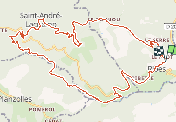

Lengte
17 km

Max. hoogte
704 m

Positief hoogteverschil
596 m
Km-Effort
25 km

Min. hoogte
241 m

Negatief hoogteverschil
609 m
Boucle
Ja
Datum van aanmaak :
2020-03-13 17:58:26.766
Laatste wijziging :
2020-03-14 10:57:17.123
5h48
Moeilijkheid : Medium

Gratisgps-wandelapplicatie
 SityTrail
IGN / Geografische instituten
SityTrail Plus
De wereld gaat voor u open
Over ons
Tocht Stappen van 17 km beschikbaar op Auvergne-Rhône-Alpes, Ardèche, Ribes. Deze tocht wordt voorgesteld door thonyc.
Plaatsbepaling
Land:
France
Regio :
Auvergne-Rhône-Alpes
Departement/Provincie :
Ardèche
Gemeente :
Ribes
Locatie:
Unknown
Vertrek:(Dec)
Vertrek:(UTM)
595991 ; 4927579 (31T) N.
Opmerkingen