


Champlon MarcheEF

thomarche
Gebruiker
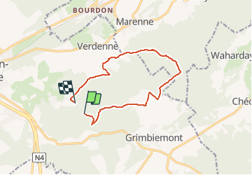

Lengte
11,3 km

Max. hoogte
402 m

Positief hoogteverschil
235 m
Km-Effort
14,5 km

Min. hoogte
300 m

Negatief hoogteverschil
256 m
Boucle
Neen
Datum van aanmaak :
2020-03-22 14:21:52.0
Laatste wijziging :
2020-03-22 16:59:02.97
2h35
Moeilijkheid : Onbekend

Gratisgps-wandelapplicatie
 SityTrail
IGN / Geografische instituten
SityTrail Plus
De wereld gaat voor u open
Over ons
Tocht Stappen van 11,3 km beschikbaar op Wallonië, Luxemburg, Marche-en-Famenne. Deze tocht wordt voorgesteld door thomarche.
Plaatsbepaling
Land:
Belgium
Regio :
Wallonië
Departement/Provincie :
Luxemburg
Gemeente :
Marche-en-Famenne
Locatie:
Waha
Vertrek:(Dec)
Vertrek:(UTM)
670649 ; 5565024 (31U) N.
Opmerkingen