


BBBBBC-17 16:44:21

UDGI54
Gebruiker
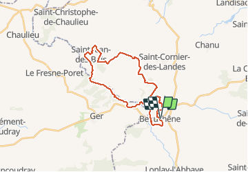

Lengte
26 km

Max. hoogte
320 m

Positief hoogteverschil
508 m
Km-Effort
33 km

Min. hoogte
166 m

Negatief hoogteverschil
506 m
Boucle
Ja
Datum van aanmaak :
2020-03-24 22:42:22.937
Laatste wijziging :
2020-03-24 22:50:08.12

Gratisgps-wandelapplicatie
 SityTrail
IGN / Geografische instituten
SityTrail Plus
De wereld gaat voor u open
Over ons
Tocht van 26 km beschikbaar op Normandië, Orne, Tinchebray-Bocage. Deze tocht wordt voorgesteld door UDGI54.
Plaatsbepaling
Land:
France
Regio :
Normandië
Departement/Provincie :
Orne
Gemeente :
Tinchebray-Bocage
Locatie:
Beauchêne
Vertrek:(Dec)
Vertrek:(UTM)
667554 ; 5394330 (30U) N.
Opmerkingen