


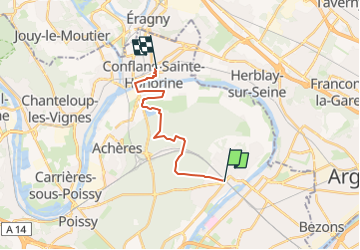
De Maisons Laffitte à Conflans Ste Honorine par la forêt

jpcccb
Gebruiker

Lengte
14 km

Max. hoogte
67 m

Positief hoogteverschil
119 m
Km-Effort
15,6 km

Min. hoogte
13 m

Negatief hoogteverschil
114 m
Boucle
Neen
Datum van aanmaak :
2020-04-06 15:36:39.568
Laatste wijziging :
2024-02-22 14:20:50.056
3h32
Moeilijkheid : Gemakkelijk

Gratisgps-wandelapplicatie
 SityTrail
IGN / Geografische instituten
SityTrail Plus
De wereld gaat voor u open
Over ons
Tocht Te voet van 14 km beschikbaar op Île-de-France, Yvelines, Maisons-Laffitte. Deze tocht wordt voorgesteld door jpcccb.
Plaatsbepaling
Land:
France
Regio :
Île-de-France
Departement/Provincie :
Yvelines
Gemeente :
Maisons-Laffitte
Locatie:
Unknown
Vertrek:(Dec)
Vertrek:(UTM)
437341 ; 5421763 (31U) N.
Opmerkingen