


11 GTMC Dio-Montagnac

nicolas54230
Gebruiker
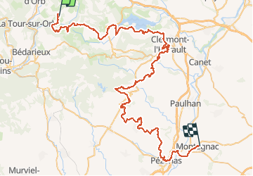

Lengte
96 km

Max. hoogte
471 m

Positief hoogteverschil
1724 m
Km-Effort
121 km

Min. hoogte
12 m

Negatief hoogteverschil
2081 m
Boucle
Neen
Datum van aanmaak :
2020-04-29 16:17:28.207
Laatste wijziging :
2020-05-03 21:15:00.442
14m
Moeilijkheid : Gemakkelijk

Gratisgps-wandelapplicatie
 SityTrail
IGN / Geografische instituten
SityTrail Plus
De wereld gaat voor u open
Over ons
Tocht Mountainbike van 96 km beschikbaar op Occitanië, Hérault, Dio-et-Valquières. Deze tocht wordt voorgesteld door nicolas54230.
Plaatsbepaling
Land:
France
Regio :
Occitanië
Departement/Provincie :
Hérault
Gemeente :
Dio-et-Valquières
Locatie:
Unknown
Vertrek:(Dec)
Vertrek:(UTM)
517237 ; 4834940 (31T) N.
Opmerkingen