


Thy-le-Bauduin

Tahir
Gebruiker
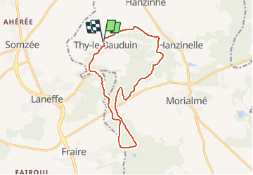

Lengte
13,2 km

Max. hoogte
281 m

Positief hoogteverschil
197 m
Km-Effort
15,8 km

Min. hoogte
192 m

Negatief hoogteverschil
199 m
Boucle
Ja
Datum van aanmaak :
2020-05-03 13:19:45.403
Laatste wijziging :
2020-05-03 14:55:20.364
1h35
Moeilijkheid : Heel gemakkelijk

Gratisgps-wandelapplicatie
 SityTrail
IGN / Geografische instituten
SityTrail Plus
De wereld gaat voor u open
Over ons
Tocht Lopen van 13,2 km beschikbaar op Wallonië, Namen, Florennes. Deze tocht wordt voorgesteld door Tahir.
Plaatsbepaling
Land:
Belgium
Regio :
Wallonië
Departement/Provincie :
Namen
Gemeente :
Florennes
Locatie:
Thy-le-Bauduin
Vertrek:(Dec)
Vertrek:(UTM)
608486 ; 5572622 (31U) N.
Opmerkingen