


Retour loges

lucmarescot
Gebruiker

Lengte
10 km

Max. hoogte
124 m

Positief hoogteverschil
90 m
Km-Effort
11,2 km

Min. hoogte
81 m

Negatief hoogteverschil
80 m
Boucle
Neen
Datum van aanmaak :
2020-05-18 14:00:32.0
Laatste wijziging :
2020-05-18 14:40:43.622
40m
Moeilijkheid : Onbekend

Gratisgps-wandelapplicatie
 SityTrail
IGN / Geografische instituten
SityTrail Plus
De wereld gaat voor u open
Over ons
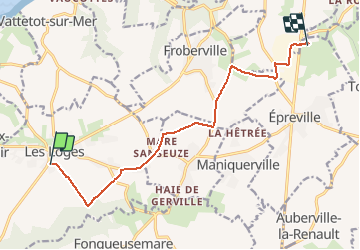
Tocht Mountainbike van 10 km beschikbaar op Normandië, Seine-Maritime, Les Loges. Deze tocht wordt voorgesteld door lucmarescot.
Plaatsbepaling
Land:
France
Regio :
Normandië
Departement/Provincie :
Seine-Maritime
Gemeente :
Les Loges
Locatie:
Unknown
Vertrek:(Dec)
Vertrek:(UTM)
303975 ; 5508406 (31U) N.
Opmerkingen