


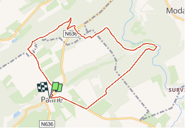
Pailhe à ancien village de Modave

LBarel
Gebruiker

Lengte
9,1 km

Max. hoogte
265 m

Positief hoogteverschil
166 m
Km-Effort
11,3 km

Min. hoogte
188 m

Negatief hoogteverschil
167 m
Boucle
Ja
Datum van aanmaak :
2020-05-19 09:15:17.006
Laatste wijziging :
2020-05-19 09:38:29.628
--
Moeilijkheid : Medium

Gratisgps-wandelapplicatie
 SityTrail
IGN / Geografische instituten
SityTrail Plus
De wereld gaat voor u open
Over ons
Tocht Te voet van 9,1 km beschikbaar op Wallonië, Luik, Clavier. Deze tocht wordt voorgesteld door LBarel.
Plaatsbepaling
Land:
Belgium
Regio :
Wallonië
Departement/Provincie :
Luik
Gemeente :
Clavier
Locatie:
Pailhe
Vertrek:(Dec)
Vertrek:(UTM)
660406 ; 5588081 (31U) N.
Opmerkingen