


Pam Boux P.A. gué

lorenzot54
Gebruiker

Lengte
36 km

Max. hoogte
360 m

Positief hoogteverschil
543 m
Km-Effort
43 km

Min. hoogte
176 m

Negatief hoogteverschil
498 m
Boucle
Neen
Datum van aanmaak :
2020-05-27 16:04:16.0
Laatste wijziging :
2020-05-27 18:48:57.561
2h06
Moeilijkheid : Onbekend

Gratisgps-wandelapplicatie
 SityTrail
IGN / Geografische instituten
SityTrail Plus
De wereld gaat voor u open
Over ons
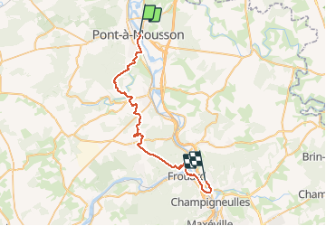
Tocht Mountainbike van 36 km beschikbaar op Grand Est, Meurthe-et-Moselle, Pont-à-Mousson. Deze tocht wordt voorgesteld door lorenzot54.
Plaatsbepaling
Land:
France
Regio :
Grand Est
Departement/Provincie :
Meurthe-et-Moselle
Gemeente :
Pont-à-Mousson
Locatie:
Unknown
Vertrek:(Dec)
Vertrek:(UTM)
284412 ; 5420987 (32U) N.
Opmerkingen