![](/images/other/stat-length.png)
![Tocht Mountainbike Wihr-au-Val - 5071881639112673 - Photo](https://media.geolcdn.com/t/1900/400/ext.pjpeg?maxdim=2&url=https%3A%2F%2Fstatic1.geolcdn.com%2Fsiteimages%2Fupload%2Ffiles%2F1524743154velo.jpg)
5071881639112673
duchaine.nicolas
Gebruiker
![Lengte](/images/other/stat-length.png)
Lengte
41 km
![Max. hoogte](https://static1.geolcdn.com/siteimages/upload/files/1508320355ic_sort_altitude_max_24dp.png)
Max. hoogte
1166 m
![Positief hoogteverschil](https://static1.geolcdn.com/siteimages/upload/files/1508320355ic_sort_den_pos_24dp.png)
Positief hoogteverschil
1355 m
![Km-Effort](/images/other/stat-length.png)
Km-Effort
59 km
![Min. hoogte](https://static1.geolcdn.com/siteimages/upload/files/1508320355ic_sort_altitude_min_24dp.png)
Min. hoogte
290 m
![Negatief hoogteverschil](https://static1.geolcdn.com/siteimages/upload/files/1508320355ic_sort_den_neg_24dp.png)
Negatief hoogteverschil
1354 m
![Boucle](https://static1.geolcdn.com/siteimages/upload/files/16400158638029165_repeat_loop_refresh_sync_direction_icon.png)
Boucle
Ja
Datum van aanmaak :
2020-05-31 16:46:03.915
Laatste wijziging :
2020-06-08 06:24:27.66
![Mountainbike](https://static1.geolcdn.com/sitytour/trail-icons/202.png)
3h47
Moeilijkheid : Medium
![Elektrische fiets](https://static1.geolcdn.com/sitytour/trail-icons/205.png)
--
Moeilijkheid : Medium
![Scan deze QR-code om de tocht te openen in de SityTrail-applicatie](https://capi.geolives.com/qq0zvz2zws4bq2lad0pu/sitytour/trails/2419692/qr.png?size=200)
Gratisgps-wandelapplicatie
Over ons
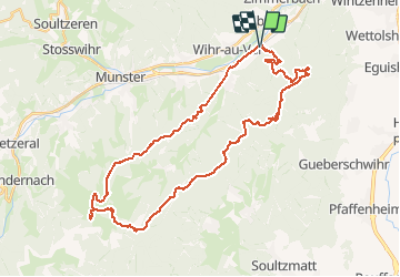
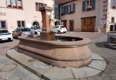
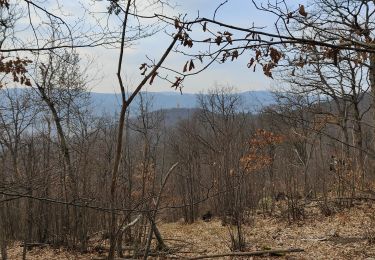
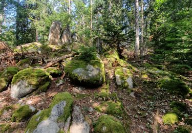
Tocht Mountainbike van 41 km beschikbaar op Grand Est, Haut-Rhin, Wihr-au-Val. Deze tocht wordt voorgesteld door duchaine.nicolas.
Beschrijving
Wirh Au Val - Stauffen - Firstplan - Boelensgrab - Col du Petit Ballon - Kahlenwasen - Ht Wasserbourg - Soultzbach
Plaatsbepaling
Land:
France
Regio :
Grand Est
Departement/Provincie :
Haut-Rhin
Gemeente :
Wihr-au-Val
Locatie:
Unknown
Vertrek:(Dec)
Vertrek:(UTM)
367654 ; 5323778 (32U) N.
Opmerkingen
Wandeltochten in de omgeving
![Tocht Stappen Wettolsheim - 4 châteaux Wettolsheim Husseren - Photo](https://media.geolcdn.com/t/375/260/ext.jpg?maxdim=2&url=https%3A%2F%2Fmedia.geolcdn.com%2Ff%2F3d38d7b6-fe96-472e-849b-8dfa9ade163e.jpg)
![Stappen Stappen](https://static1.geolcdn.com/sitytour/trail-icons/101.png)
4 châteaux Wettolsheim Husseren
Stappen
Medium
(1)
Wettolsheim,
Grand Est,
Haut-Rhin,
France
![](/images/other/stat-length.png)
11,7 km | 17,7 km-effort
4h 28min
![](https://static1.geolcdn.com/siteimages/upload/files/16400158638029165_repeat_loop_refresh_sync_direction_icon.png)
Neen
![Tocht Mountainbike Wintzenheim - Wintzenheim - Le Stauffen - Col de Marbach - Soultzbach - Photo](https://media.geolcdn.com/t/375/260/ext.jpg?maxdim=2&url=https%3A%2F%2Fstatic1.geolcdn.com%2Fsiteimages%2Fupload%2Ffiles%2F1524743154velo.jpg)
![Mountainbike Mountainbike](https://static1.geolcdn.com/sitytour/trail-icons/202.png)
Wintzenheim - Le Stauffen - Col de Marbach - Soultzbach
Mountainbike
Medium
(1)
Wintzenheim,
Grand Est,
Haut-Rhin,
France
![](/images/other/stat-length.png)
23 km | 31 km-effort
2h 4min
![](https://static1.geolcdn.com/siteimages/upload/files/16400158638029165_repeat_loop_refresh_sync_direction_icon.png)
Ja
![Tocht Stappen Wintzenheim - Château de Pflixbourg depuis Saint Gilles - Photo](https://media.geolcdn.com/t/375/260/ext.jpg?maxdim=2&url=https%3A%2F%2Fstatic1.geolcdn.com%2Fsiteimages%2Fupload%2Ffiles%2F1553511878bg_sport_marche.png)
![Stappen Stappen](https://static1.geolcdn.com/sitytour/trail-icons/101.png)
Château de Pflixbourg depuis Saint Gilles
Stappen
Gemakkelijk
(1)
Wintzenheim,
Grand Est,
Haut-Rhin,
France
![](/images/other/stat-length.png)
3,7 km | 6,2 km-effort
1h 21min
![](https://static1.geolcdn.com/siteimages/upload/files/16400158638029165_repeat_loop_refresh_sync_direction_icon.png)
Ja
![Tocht Te voet Walbach - wihr au val - le petit hohnack - Photo](https://media.geolcdn.com/t/375/260/ext.jpg?maxdim=2&url=https%3A%2F%2Fstatic1.geolcdn.com%2Fsiteimages%2Fupload%2Ffiles%2F1545311037marcheuse_200dpi.jpg)
![Te voet Te voet](https://static1.geolcdn.com/sitytour/trail-icons/100.png)
wihr au val - le petit hohnack
Te voet
Medium
(1)
Walbach,
Grand Est,
Haut-Rhin,
France
![](/images/other/stat-length.png)
15,6 km | 25 km-effort
5h 46min
![](https://static1.geolcdn.com/siteimages/upload/files/16400158638029165_repeat_loop_refresh_sync_direction_icon.png)
Ja
![Tocht Stappen Husseren-les-Châteaux - Husseren les Châteaux - Photo](https://media.geolcdn.com/t/375/260/ext.jpg?maxdim=2&url=https%3A%2F%2Fmedia.geolcdn.com%2Ff%2Ffbdaec15-f3be-4264-9cbd-289a37b2f125.jpg)
![Stappen Stappen](https://static1.geolcdn.com/sitytour/trail-icons/101.png)
Husseren les Châteaux
Stappen
Gemakkelijk
Husseren-les-Châteaux,
Grand Est,
Haut-Rhin,
France
![](/images/other/stat-length.png)
12,7 km | 19,1 km-effort
3h 24min
![](https://static1.geolcdn.com/siteimages/upload/files/16400158638029165_repeat_loop_refresh_sync_direction_icon.png)
Ja
![Tocht Wegfiets Turckheim - Véloroute du vignoble - Photo](https://media.geolcdn.com/t/375/260/ext.jpg?maxdim=2&url=https%3A%2F%2Fmedia.geolcdn.com%2Ff%2F9263e08a-0b4f-48c2-a8aa-77b96268d9df.jpg)
![Wegfiets Wegfiets](https://static1.geolcdn.com/sitytour/trail-icons/201.png)
Véloroute du vignoble
Wegfiets
Medium
Turckheim,
Grand Est,
Haut-Rhin,
France
![](/images/other/stat-length.png)
55 km | 61 km-effort
3h 31min
![](https://static1.geolcdn.com/siteimages/upload/files/16400158638029165_repeat_loop_refresh_sync_direction_icon.png)
Neen
![Tocht Stappen Gunsbach - Gunsbach - Munster - Photo](https://media.geolcdn.com/t/375/260/ext.jpg?maxdim=2&url=https%3A%2F%2Fmedia.geolcdn.com%2Ff%2Ff19a3bd4-4012-483c-b25e-87971c814e55.jpg)
![Stappen Stappen](https://static1.geolcdn.com/sitytour/trail-icons/101.png)
Gunsbach - Munster
Stappen
Moeilijk
Gunsbach,
Grand Est,
Haut-Rhin,
France
![](/images/other/stat-length.png)
11,8 km | 18,3 km-effort
4h 9min
![](https://static1.geolcdn.com/siteimages/upload/files/16400158638029165_repeat_loop_refresh_sync_direction_icon.png)
Ja
![Tocht Stappen Wintzenheim - Boucle de la fontaine de la dame - Photo](https://media.geolcdn.com/t/375/260/ext.jpg?maxdim=2&url=https%3A%2F%2Fmedia.geolcdn.com%2Ff%2Fee79f3ee-48dc-4e78-8e39-2ea9fd8c2e7b.jpg)
![Stappen Stappen](https://static1.geolcdn.com/sitytour/trail-icons/101.png)
Boucle de la fontaine de la dame
Stappen
Medium
Wintzenheim,
Grand Est,
Haut-Rhin,
France
![](/images/other/stat-length.png)
7,9 km | 12,6 km-effort
2h 0min
![](https://static1.geolcdn.com/siteimages/upload/files/16400158638029165_repeat_loop_refresh_sync_direction_icon.png)
Ja
![Tocht Stappen Wintzenheim - rdpr witzenheim 210907 - Photo](https://media.geolcdn.com/t/375/260/ext.jpg?maxdim=2&url=https%3A%2F%2Fmedia.geolcdn.com%2Ff%2F9c47c5fe-7724-42e4-930a-f4b739a4c5a4.jpg)
![Stappen Stappen](https://static1.geolcdn.com/sitytour/trail-icons/101.png)
rdpr witzenheim 210907
Stappen
Zeer moeilijk
Wintzenheim,
Grand Est,
Haut-Rhin,
France
![](/images/other/stat-length.png)
16,2 km | 24 km-effort
5h 52min
![](https://static1.geolcdn.com/siteimages/upload/files/16400158638029165_repeat_loop_refresh_sync_direction_icon.png)
Ja