


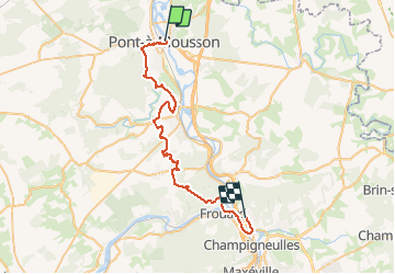
PONT-à-MOUSSON Bouxières-aux-Dames

lorenzot54
Gebruiker

Lengte
40 km

Max. hoogte
360 m

Positief hoogteverschil
727 m
Km-Effort
49 km

Min. hoogte
178 m

Negatief hoogteverschil
683 m
Boucle
Neen
Datum van aanmaak :
2020-06-02 15:15:12.0
Laatste wijziging :
2020-06-04 11:13:09.418
2h29
Moeilijkheid : Onbekend

Gratisgps-wandelapplicatie
 SityTrail
IGN / Geografische instituten
SityTrail Plus
De wereld gaat voor u open
Over ons
Tocht Mountainbike van 40 km beschikbaar op Grand Est, Meurthe-et-Moselle, Pont-à-Mousson. Deze tocht wordt voorgesteld door lorenzot54.
Beschrijving
Par Maidieres, Dieulouard, Marbache, Pompey avec de nombreux cingle.
Plaatsbepaling
Land:
France
Regio :
Grand Est
Departement/Provincie :
Meurthe-et-Moselle
Gemeente :
Pont-à-Mousson
Locatie:
Unknown
Vertrek:(Dec)
Vertrek:(UTM)
284292 ; 5420900 (32U) N.
Opmerkingen