


conde sur seulles 11 kms 2020

aubinjoel
Gebruiker
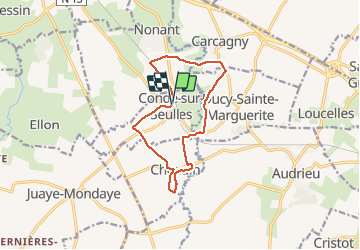

Lengte
11,1 km

Max. hoogte
81 m

Positief hoogteverschil
106 m
Km-Effort
12,5 km

Min. hoogte
32 m

Negatief hoogteverschil
102 m
Boucle
Ja
Datum van aanmaak :
2020-06-09 09:11:36.445
Laatste wijziging :
2020-06-09 09:13:08.394

Gratisgps-wandelapplicatie
 SityTrail
IGN / Geografische instituten
SityTrail Plus
De wereld gaat voor u open
Over ons
Tocht van 11,1 km beschikbaar op Normandië, Calvados. Deze tocht wordt voorgesteld door aubinjoel.
Plaatsbepaling
Land:
France
Regio :
Normandië
Departement/Provincie :
Calvados
Gemeente :
CONDE-SUR-SEULLES
Locatie:
Unknown
Vertrek:(Dec)
Vertrek:(UTM)
672193 ; 5455219 (30U) N.
Opmerkingen