


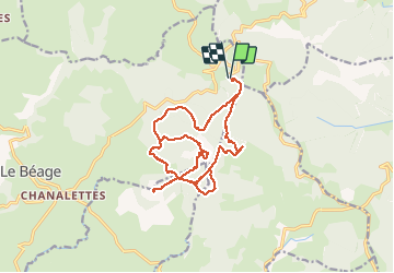
Les 4 sucs

alinetpierre
Gebruiker

Lengte
21 km

Max. hoogte
1585 m

Positief hoogteverschil
575 m
Km-Effort
28 km

Min. hoogte
1402 m

Negatief hoogteverschil
582 m
Boucle
Ja
Datum van aanmaak :
2020-06-24 07:08:48.0
Laatste wijziging :
2020-06-24 15:04:25.227
7h33
Moeilijkheid : Moeilijk

Gratisgps-wandelapplicatie
 SityTrail
IGN / Geografische instituten
SityTrail Plus
De wereld gaat voor u open
Over ons
Tocht Stappen van 21 km beschikbaar op Auvergne-Rhône-Alpes, Ardèche, Le Béage. Deze tocht wordt voorgesteld door alinetpierre.
Beschrijving
Cool mais difficile aux intersections car les sentiers nons entretenus , pour cause de coronavirus
Plaatsbepaling
Land:
France
Regio :
Auvergne-Rhône-Alpes
Departement/Provincie :
Ardèche
Gemeente :
Le Béage
Locatie:
Unknown
Vertrek:(Dec)
Vertrek:(UTM)
593460 ; 4969199 (31T) N.
Opmerkingen