


rene st germain

coglais
Gebruiker

Lengte
9,9 km

Max. hoogte
194 m

Positief hoogteverschil
186 m
Km-Effort
12,4 km

Min. hoogte
120 m

Negatief hoogteverschil
186 m
Boucle
Ja
Datum van aanmaak :
2020-06-25 07:11:56.844
Laatste wijziging :
2020-06-25 09:34:04.47
2h20
Moeilijkheid : Medium

Gratisgps-wandelapplicatie
 SityTrail
IGN / Geografische instituten
SityTrail Plus
De wereld gaat voor u open
Over ons
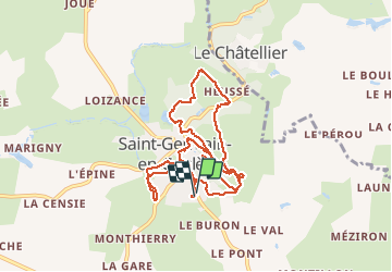
Tocht Noords wandelen van 9,9 km beschikbaar op Bretagne, Ille-et-Vilaine, Saint-Germain-en-Coglès. Deze tocht wordt voorgesteld door coglais.
Plaatsbepaling
Land:
France
Regio :
Bretagne
Departement/Provincie :
Ille-et-Vilaine
Gemeente :
Saint-Germain-en-Coglès
Locatie:
Unknown
Vertrek:(Dec)
Vertrek:(UTM)
628730 ; 5362346 (30U) N.
Opmerkingen