


Ticknock WL route 2014

mickhanney
Gebruiker
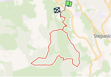

Lengte
8,2 km

Max. hoogte
463 m

Positief hoogteverschil
331 m
Km-Effort
12,5 km

Min. hoogte
173 m

Negatief hoogteverschil
294 m
Boucle
Neen
Datum van aanmaak :
2014-12-10 00:00:00.0
Laatste wijziging :
2014-12-10 00:00:00.0
--
Moeilijkheid : Moeilijk

Gratisgps-wandelapplicatie
 SityTrail
IGN / Geografische instituten
SityTrail Plus
De wereld gaat voor u open
Over ons
Tocht Lopen van 8,2 km beschikbaar op Onbekend, Onbekend, Onbekend. Deze tocht wordt voorgesteld door mickhanney.
Plaatsbepaling
Land:
Ireland
Regio :
Onbekend
Departement/Provincie :
Onbekend
Gemeente :
Onbekend
Locatie:
Glencullen ED
Vertrek:(Dec)
Vertrek:(UTM)
684323 ; 5904939 (29U) N.
Opmerkingen