


Andenne - Coutisse

thomarche
Gebruiker
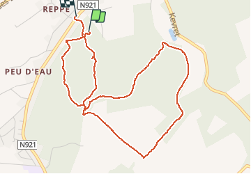

Lengte
5,2 km

Max. hoogte
231 m

Positief hoogteverschil
123 m
Km-Effort
6,9 km

Min. hoogte
127 m

Negatief hoogteverschil
155 m
Boucle
Ja
Datum van aanmaak :
2020-06-28 13:07:12.0
Laatste wijziging :
2020-06-28 14:44:17.826
1h36
Moeilijkheid : Onbekend

Gratisgps-wandelapplicatie
 SityTrail
IGN / Geografische instituten
SityTrail Plus
De wereld gaat voor u open
Over ons
Tocht Stappen van 5,2 km beschikbaar op Wallonië, Namen, Andenne. Deze tocht wordt voorgesteld door thomarche.
Beschrijving
Croisé ligne hte tension, magnifiquissime portion ancien vicinal
Plaatsbepaling
Land:
Belgium
Regio :
Wallonië
Departement/Provincie :
Namen
Gemeente :
Andenne
Locatie:
Andenne
Vertrek:(Dec)
Vertrek:(UTM)
649286 ; 5593989 (31U) N.
Opmerkingen