


Vedrenne (MarcheEF)

thomarche
Gebruiker
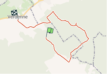

Lengte
7,5 km

Max. hoogte
402 m

Positief hoogteverschil
110 m
Km-Effort
9,2 km

Min. hoogte
297 m

Negatief hoogteverschil
197 m
Boucle
Neen
Datum van aanmaak :
2020-07-05 13:45:36.0
Laatste wijziging :
2020-07-11 14:03:42.622
1h46
Moeilijkheid : Onbekend

Gratisgps-wandelapplicatie
 SityTrail
IGN / Geografische instituten
SityTrail Plus
De wereld gaat voor u open
Over ons
Tocht Stappen van 7,5 km beschikbaar op Wallonië, Luxemburg, Marche-en-Famenne. Deze tocht wordt voorgesteld door thomarche.
Plaatsbepaling
Land:
Belgium
Regio :
Wallonië
Departement/Provincie :
Luxemburg
Gemeente :
Marche-en-Famenne
Locatie:
Waha
Vertrek:(Dec)
Vertrek:(UTM)
672238 ; 5566599 (31U) N.
Opmerkingen