


descente 1

DaVinci
Gebruiker

Lengte
10,7 km

Max. hoogte
60 m

Positief hoogteverschil
37 m
Km-Effort
11,2 km

Min. hoogte
47 m

Negatief hoogteverschil
40 m
Boucle
Neen
Datum van aanmaak :
2020-07-13 10:39:29.033
Laatste wijziging :
2020-07-13 12:04:18.658
1h21
Moeilijkheid : Heel gemakkelijk

Gratisgps-wandelapplicatie
 SityTrail
IGN / Geografische instituten
SityTrail Plus
De wereld gaat voor u open
Over ons
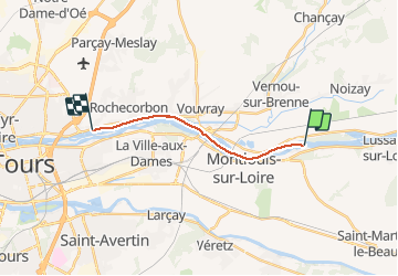
Tocht Kanoën - kajakken van 10,7 km beschikbaar op Centre-Val de Loire, Indre-et-Loire, Vernou-sur-Brenne. Deze tocht wordt voorgesteld door DaVinci.
Plaatsbepaling
Land:
France
Regio :
Centre-Val de Loire
Departement/Provincie :
Indre-et-Loire
Gemeente :
Vernou-sur-Brenne
Locatie:
Unknown
Vertrek:(Dec)
Vertrek:(UTM)
338836 ; 5251555 (31T) N.
Opmerkingen