


Lustin après Belvédère

thomarche
Gebruiker
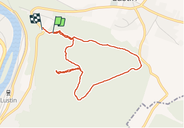

Lengte
4,3 km

Max. hoogte
278 m

Positief hoogteverschil
85 m
Km-Effort
5,5 km

Min. hoogte
173 m

Negatief hoogteverschil
114 m
Boucle
Ja
Datum van aanmaak :
2020-07-13 13:07:12.0
Laatste wijziging :
2020-07-13 14:12:26.927
1h04
Moeilijkheid : Onbekend

Gratisgps-wandelapplicatie
 SityTrail
IGN / Geografische instituten
SityTrail Plus
De wereld gaat voor u open
Over ons
Tocht Stappen van 4,3 km beschikbaar op Wallonië, Namen, Profondeville. Deze tocht wordt voorgesteld door thomarche.
Beschrijving
Parfait pr digérer d’une bonne truite au Belvédère
Plaatsbepaling
Land:
Belgium
Regio :
Wallonië
Departement/Provincie :
Namen
Gemeente :
Profondeville
Locatie:
Lustin
Vertrek:(Dec)
Vertrek:(UTM)
633996 ; 5582073 (31U) N.
Opmerkingen