


Vienne

Arnaud Dejean
Gebruiker
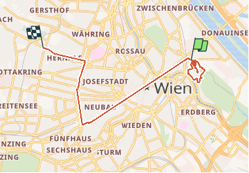

Lengte
14,3 km

Max. hoogte
222 m

Positief hoogteverschil
184 m
Km-Effort
16,5 km

Min. hoogte
154 m

Negatief hoogteverschil
134 m
Boucle
Neen
Datum van aanmaak :
2020-07-22 07:41:42.601
Laatste wijziging :
2020-07-22 13:29:33.698
5h44
Moeilijkheid : Gemakkelijk

Gratisgps-wandelapplicatie
 SityTrail
IGN / Geografische instituten
SityTrail Plus
De wereld gaat voor u open
Over ons
Tocht Stappen van 14,3 km beschikbaar op Wenen, Onbekend, Onbekend. Deze tocht wordt voorgesteld door Arnaud Dejean.
Plaatsbepaling
Land:
Austria
Regio :
Wenen
Departement/Provincie :
Onbekend
Gemeente :
Onbekend
Locatie:
Leopoldstadt
Vertrek:(Dec)
Vertrek:(UTM)
603585 ; 5341418 (33U) N.
Opmerkingen