


Aérodrome Sud Meusien

flzanichelli
Gebruiker

Lengte
4,8 km

Max. hoogte
263 m

Positief hoogteverschil
64 m
Km-Effort
5,6 km

Min. hoogte
206 m

Negatief hoogteverschil
64 m
Boucle
Ja
Datum van aanmaak :
2020-07-28 17:25:02.136
Laatste wijziging :
2020-07-28 17:55:00.365
29m
Moeilijkheid : Heel gemakkelijk

Gratisgps-wandelapplicatie
 SityTrail
IGN / Geografische instituten
SityTrail Plus
De wereld gaat voor u open
Over ons
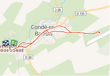
Tocht Elektrische fiets van 4,8 km beschikbaar op Grand Est, Meuse, Les Hauts-de-Chée. Deze tocht wordt voorgesteld door flzanichelli.
Plaatsbepaling
Land:
France
Regio :
Grand Est
Departement/Provincie :
Meuse
Gemeente :
Les Hauts-de-Chée
Locatie:
Unknown
Vertrek:(Dec)
Vertrek:(UTM)
658256 ; 5414627 (31U) N.
Opmerkingen