


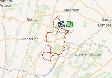
Simorre

kipoura
Gebruiker

Lengte
61 km

Max. hoogte
350 m

Positief hoogteverschil
1303 m
Km-Effort
79 km

Min. hoogte
194 m

Negatief hoogteverschil
1302 m
Boucle
Ja
Datum van aanmaak :
2020-07-29 16:23:30.604
Laatste wijziging :
2020-07-29 16:43:24.386
5h09
Moeilijkheid : Zeer moeilijk

Gratisgps-wandelapplicatie
 SityTrail
IGN / Geografische instituten
SityTrail Plus
De wereld gaat voor u open
Over ons
Tocht Mountainbike van 61 km beschikbaar op Occitanië, Gers, Simorre. Deze tocht wordt voorgesteld door kipoura.
Plaatsbepaling
Land:
France
Regio :
Occitanië
Departement/Provincie :
Gers
Gemeente :
Simorre
Locatie:
Unknown
Vertrek:(Dec)
Vertrek:(UTM)
316940 ; 4813858 (31T) N.
Opmerkingen