


7980102

jeanboulay
Gebruiker
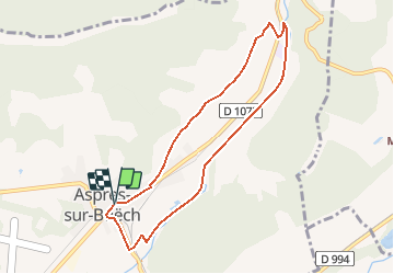

Lengte
8 km

Max. hoogte
798 m

Positief hoogteverschil
66 m
Km-Effort
8,9 km

Min. hoogte
754 m

Negatief hoogteverschil
67 m
Boucle
Ja
Datum van aanmaak :
2020-07-31 12:19:09.272
Laatste wijziging :
2020-07-31 12:19:09.272
--
Moeilijkheid : Onbekend

Gratisgps-wandelapplicatie
 SityTrail
IGN / Geografische instituten
SityTrail Plus
De wereld gaat voor u open
Over ons
Tocht Mountainbike van 8 km beschikbaar op Provence-Alpes-Côte d'Azur, Hautes-Alpes, Aspres-sur-Buëch. Deze tocht wordt voorgesteld door jeanboulay.
Plaatsbepaling
Land:
France
Regio :
Provence-Alpes-Côte d'Azur
Departement/Provincie :
Hautes-Alpes
Gemeente :
Aspres-sur-Buëch
Locatie:
Unknown
Vertrek:(Dec)
Vertrek:(UTM)
718729 ; 4933546 (31T) N.
Opmerkingen