


Ymare - Version 2020 -9 km

MichelRando7656
Gebruiker
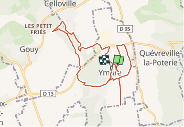

Lengte
10,1 km

Max. hoogte
146 m

Positief hoogteverschil
130 m
Km-Effort
11,9 km

Min. hoogte
91 m

Negatief hoogteverschil
129 m
Boucle
Ja
Datum van aanmaak :
2020-08-04 07:07:10.345
Laatste wijziging :
2021-07-18 22:22:26.274
2h43
Moeilijkheid : Heel gemakkelijk

Gratisgps-wandelapplicatie
 SityTrail
IGN / Geografische instituten
SityTrail Plus
De wereld gaat voor u open
Over ons
Tocht Stappen van 10,1 km beschikbaar op Normandië, Seine-Maritime, Ymare. Deze tocht wordt voorgesteld door MichelRando7656.
Beschrijving
Sentiers très variés. Bois et.campagne . Petits sentiers deville entre les haies.
Foto's


Plaatsbepaling
Land:
France
Regio :
Normandië
Departement/Provincie :
Seine-Maritime
Gemeente :
Ymare
Locatie:
Unknown
Vertrek:(Dec)
Vertrek:(UTM)
367494 ; 5467934 (31U) N.
Opmerkingen