


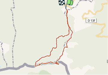
pic des salines depuis fontfrede via coll del pou de la neu . pic des salines .coll des cirerers . fontfrede

stef789
Gebruiker GUIDE

Lengte
9,3 km

Max. hoogte
1322 m

Positief hoogteverschil
467 m
Km-Effort
15,6 km

Min. hoogte
968 m

Negatief hoogteverschil
462 m
Boucle
Ja
Datum van aanmaak :
2020-08-05 11:05:50.043
Laatste wijziging :
2020-08-05 17:29:58.354
3h48
Moeilijkheid : Gemakkelijk

Gratisgps-wandelapplicatie
 SityTrail
IGN / Geografische instituten
SityTrail Plus
De wereld gaat voor u open
Over ons
Tocht Stappen van 9,3 km beschikbaar op Occitanië, Pyrénées-Orientales, Céret. Deze tocht wordt voorgesteld door stef789.
Foto's


Plaatsbepaling
Land:
France
Regio :
Occitanië
Departement/Provincie :
Pyrénées-Orientales
Gemeente :
Céret
Locatie:
Unknown
Vertrek:(Dec)
Vertrek:(UTM)
480062 ; 4699553 (31T) N.
Opmerkingen