


sirod

jojo02
Gebruiker
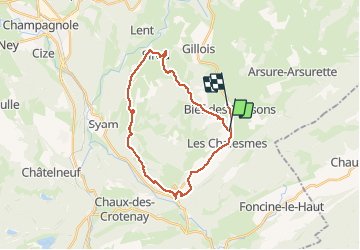

Lengte
26 km

Max. hoogte
944 m

Positief hoogteverschil
507 m
Km-Effort
33 km

Min. hoogte
609 m

Negatief hoogteverschil
507 m
Boucle
Neen
Datum van aanmaak :
2020-08-06 07:43:31.175
Laatste wijziging :
2020-08-06 10:33:27.776
2h48
Moeilijkheid : Medium

Gratisgps-wandelapplicatie
 SityTrail
IGN / Geografische instituten
SityTrail Plus
De wereld gaat voor u open
Over ons
Tocht Mountainbike van 26 km beschikbaar op Bourgondië-Franche-Comté, Jura, Les Chalesmes. Deze tocht wordt voorgesteld door jojo02.
Plaatsbepaling
Land:
France
Regio :
Bourgondië-Franche-Comté
Departement/Provincie :
Jura
Gemeente :
Les Chalesmes
Locatie:
Unknown
Vertrek:(Dec)
Vertrek:(UTM)
273558 ; 5175506 (32T) N.
Opmerkingen